
Stockpile Volume Survey
Know exactly how much stock you hold, without walking the piles.
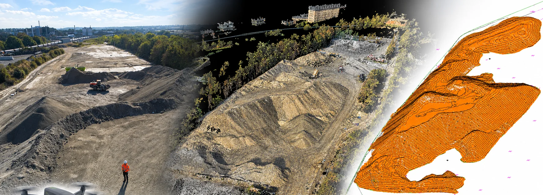
We fly a drone over your stockpiles, build a detailed 3D model of the site and calculate the volume of material present. It is quicker and safer than measuring on foot, and it gives you a clear, repeatable figure in cubic metres for stock control, reporting and valuation.
About This Service
Stockpile Volume Survey, explained
Measuring stock from the air
Stockpiles are awkward to measure. They are large, the surface is uneven and the material can be unstable, so walking the piles with GPS or a total station is slow and puts people on or beside moving plant and loose ground. A drone removes most of that. It captures the whole surface from above in a short flight, with the site carrying on working around it.
The result is a measured 3D model of every pile, from which we calculate how much material is there.
From images to a volume
Our pilot flies the site collecting overlapping images, which are processed into a detailed point cloud and surface model. Ground control keeps the model tied to a known position so results are consistent from one survey to the next.
Each stockpile is then defined precisely, and its volume is calculated as the space between the surface of the pile and a base surface. How that base is set matters, particularly where the ground under the pile is uneven, so we agree it with you rather than leaving it to a default.
Where it is used
Quarries, aggregate and recycling yards use volume surveys for stock control, reporting and valuation. Contractors use them to measure spoil and imported fill on earthworks projects, and to check quantities against what has been moved or paid for.
Because the method is repeatable, regular surveys build a clear picture of how stock changes over time, and the same data can feed a topographic survey or surface model of the site when you need one.
Who It's For
Built around what you need
- 01
Quarries, aggregate & recycling operators
Reliable stock figures for management accounts, audits and planning deliveries.
- 02
Contractors & earthworks teams
Spoil, imported fill and material stockpiles measured on large or busy sites.
- 03
Site managers & operations teams
Regular volume checks without anyone climbing or walking on unstable piles.
- 04
Accountants, valuers & stock auditors
A documented, measured basis for stock quantities and period-end valuation.
Deliverables
What you receive
- Stockpile volumes in cubic metres, pile by pile
- Volume report and plan showing each stockpile outline
- 3D surface model and point cloud of the site
- Contours and topographic data on request
- Repeat surveys to compare volumes between visits
How It Works
From enquiry to delivered data
- 01
Aerial capture
Our pilot flies the stockpiles with a drone, collecting overlapping imagery quickly and safely.
- 02
3D site model
The imagery is processed into a high-detail point cloud that accurately represents each pile.
- 03
Survey & modelling
We turn the data into topographic information and a surface model, with each stockpile precisely defined.
- 04
Volume calculation
Volumes are calculated against an agreed base surface and reported in m³.
FAQs
Common questions
How accurate is a drone stockpile survey?
Independent studies show drone photogrammetry can measure stockpile volumes to within a few percent, and often better. The result depends on the flight, the ground control, the surface of the pile and how the base is defined, so we agree the accuracy you need before we fly.
Do you need to walk on the stockpiles?
No. The drone captures the surface from above, so nobody needs to climb or walk on the material, which is safer on tall or unstable piles.
Can you survey the same site regularly?
Yes. Repeat surveys use the same method, so volumes can be compared between visits to show how stock has changed over time.
Can you measure vegetation-covered or partly hidden piles?
Dense vegetation or material hidden from the camera can reduce accuracy. Tell us about the site and we will advise whether a drone survey suits it or whether another method would be better.
Get in Touch
Ready to Start
Your Project?
Tell us about your project and we'll get back to you with a tailored quote. No fixed daily rates — we price based on your specific requirements.
What to expect
- 01
Tell us about your project
Share your requirements, site details, and any drawings you have. We'll review everything before quoting.
- 02
We send a tailored quote
Pricing based on your specific needs — not generic day rates. Transparent and competitive.
- 03
We survey your site
Our qualified team arrive with the relevant equipment to carry out the survey.
- 04
Receive your survey data
Accurate CAD files, point cloud data, BIM models — delivered to your specification, on time.